Earith Bulwark: Exploring a 17th-Century Civil War Fort

Earith Bulwark: Exploring a 17th-Century Civil War Fort
Hidden away in the Cambridgeshire countryside is an impressive reminder of one of the most turbulent periods in English history.
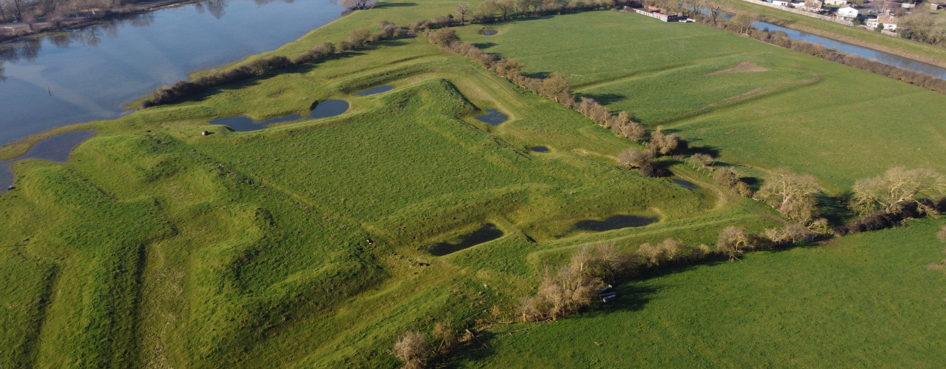
Earith Bulwark is the surviving earthwork of a Civil War fortification built during the English Civil War, when Parliamentarian forces were defending the approaches to the Isle of Ely.
Today, much of what remains looks like little more than banks, ditches and grassy earthworks.
But once you understand what you’re looking at, the shape of the fort begins to make sense.
And because I happened to have a drone with me, I decided to take a look from above.
Watch the video
What is Earith Bulwark?
The Earith Bulwark is a remarkably well-preserved Civil War fieldwork situated just to the east of Earith in Cambridgeshire.
It was constructed by Parliamentarian forces during the first stage of the English Civil War, probably between 1643 and 1645.
The fort was designed to protect an important crossing and control movement through the surrounding Fenland landscape.
Today, it is a Scheduled Monument, reflecting its national archaeological and historical importance. Historic England describes it as one of the most elaborate surviving English Civil War fortifications in England.
And that’s quite a claim for something that, from ground level, can initially look like a few unusually large grassy banks.
Why was a fort built at Earith?
The location makes much more sense when you look at the landscape.
During the Civil War, the Fenland waterways and causeways were important lines of communication.
Earith was strategically positioned near an important crossing towards the Isle of Ely, while the surrounding waterways provided additional routes through the Fens.
The Bulwark was positioned to command the crossing at the western end of the fen causeway linking Huntingdon with the Isle of Ely.
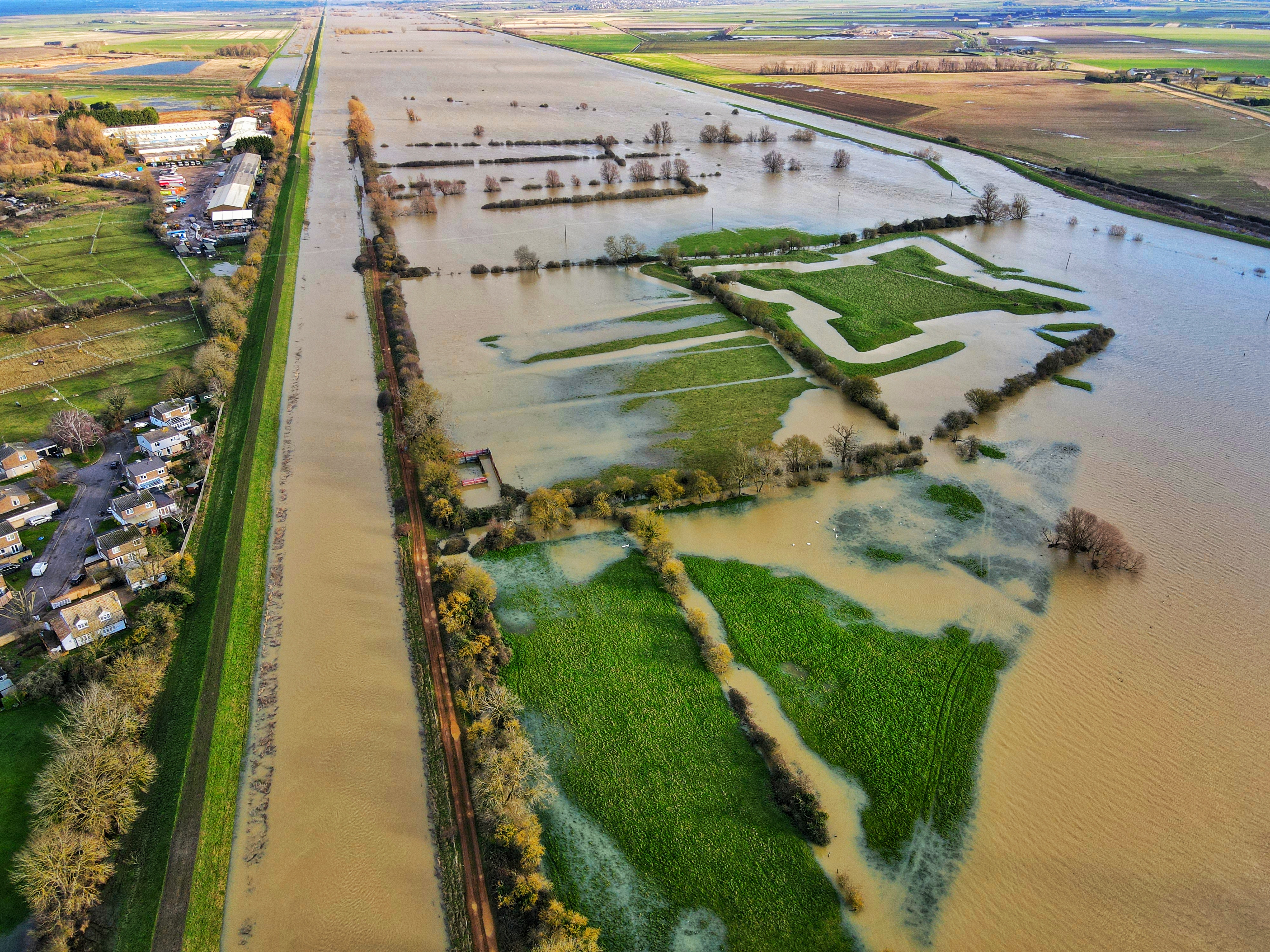
It also overlooked routes along the River Great Ouse and the Old Bedford River, the latter being one of the artificial waterways constructed during the drainage of the Fens in the 1630s.
In other words, this wasn’t a fort built in a random field.
It was positioned where it could control movement through a strategically important part of the landscape.
The English Civil War
The English Civil War began in 1642, when conflict broke out between supporters of King Charles I and Parliament.
Cambridgeshire and the surrounding eastern counties became particularly important to the Parliamentarian cause.
The region formed part of the Eastern Association, a powerful grouping of Parliamentarian counties whose forces played an important role during the war.
The Fens were especially valuable because their waterways, crossings and difficult terrain provided natural defensive advantages.
The Isle of Ely itself was an important stronghold, and controlling the approaches to it was therefore a military priority.
Historic England believes that the Bulwark was constructed as part of this wider effort to strengthen the Parliamentarian frontier around the Isle of Ely.
Was Earith Bulwark actually used in battle?
This is one of the more interesting things about the site.
Despite being built during a civil war, Earith Bulwark apparently never saw major military action.
It was part of a defensive network intended to prevent an enemy force from advancing through the Fens and threatening the Isle of Ely.
The threat was real enough to justify building the fort.
But the battle that the fort was designed to prepare for never actually came.
Historic England notes that the Bulwark, like several other East Anglian Civil War fortifications, appears never to have seen action.
So what survives today is essentially a military installation that was prepared for a battle that never arrived.
What did the original fort look like?
This is where the site becomes particularly interesting.
The surviving earthworks aren’t simply one large mound.
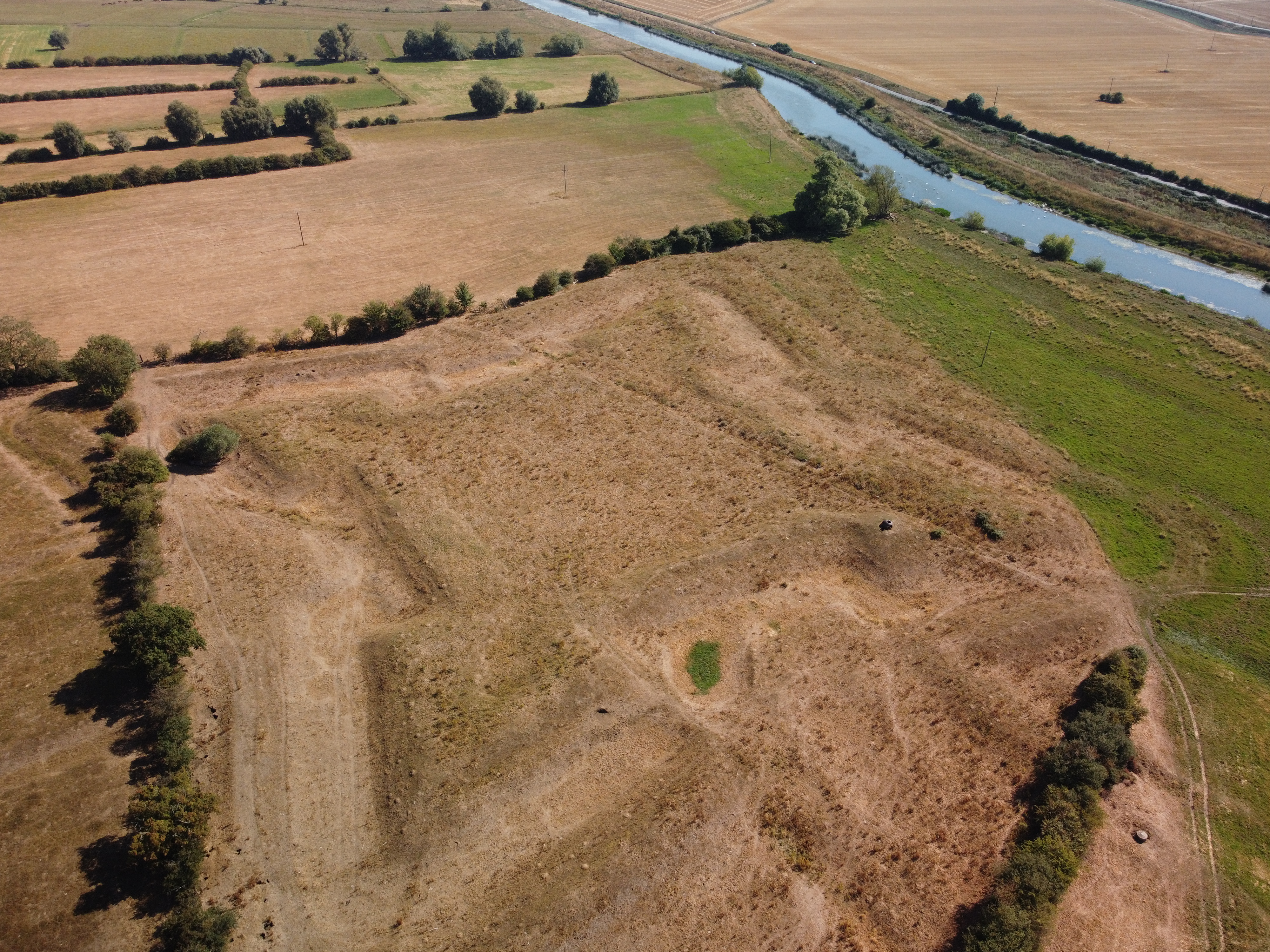
The fort had a square central enclosure, surrounded by banks, ditches and defensive features.
The central enclosure measures roughly 60 metres square and was raised above the surrounding ground.
There were also corner bastions and additional outworks extending from the main fortification.
These features allowed defenders to protect the fort from different directions.
The shape also reflects contemporary developments in military engineering.
Historic England says the design shows clear influences from the Dutch school of fortification, which was highly influential in European military engineering at the time.
So although it may look like a simple earthwork today, the Bulwark was actually a carefully designed defensive structure.
Bastions, ditches and outworks
One of the reasons Earith Bulwark is so important is the amount of detail that survives.
The banks, parapets and bastions still retain evidence of how the fort was constructed.
There were also substantial ditches surrounding the main enclosure.
Some of these features can be difficult to appreciate when you’re standing at ground level.
That’s one reason I wanted to see the site from the air.
From above, the outline becomes much easier to understand.
The geometry of the fort starts to appear, and what initially looks like a collection of random earth banks suddenly reveals itself as a deliberately designed military installation.
Why the Fenland landscape mattered
The Fens were a very different environment in the 17th century.
Waterways and drainage channels were important transportation routes, while the relatively flat and wet landscape could make movement difficult for an invading army.
Earith’s position between important waterways gave the fort an additional strategic advantage.
The Bulwark was located between the Old and New Bedford Rivers, close to the Great Ouse.
This meant the fort could help control both land and water routes through the area.
The surrounding landscape therefore wasn’t just the backdrop to the fort.
It was part of the defence.
The fort and Oliver Cromwell
It’s tempting to describe Earith Bulwark simply as one of Oliver Cromwell’s forts, but the reality is a little more complicated.
Cromwell was an important Parliamentarian military commander in the Eastern Association and was involved in organising the region’s defences.
However, Historic England suggests that the precise construction date and circumstances of the Bulwark aren’t certain.
It may have been built following the Royalist rebellion on the Isle of Ely in 1643, or potentially during subsequent efforts to strengthen the region’s defences.
So while Cromwell is an important part of the wider story, it would be misleading to claim that he personally designed or built Earith Bulwark.
An archaeological time capsule
There’s another reason the site is important.
The earthworks haven’t simply survived because they’re big.
The surrounding ditches contain deposits of waterlogged silt, which can help preserve organic and inorganic archaeological material.
That makes the site potentially valuable for understanding not just how the fort was constructed, but also what happened during its occupation.
Archaeological investigations have continued to add to our understanding of the area.
A more recent archaeological project examined trenches around the Bulwark and found evidence including 17th-century pottery in one of the investigated areas.
That might not sound particularly exciting compared with discovering a sword or cannon.
But for archaeologists, even fragments of pottery can help connect the surviving earthworks with the people who actually occupied and used the site.
And then came the Second World War
There’s a fantastic twist to the history of Earith Bulwark.
The site wasn’t completely forgotten after the Civil War.
More than 250 years later, during World War II, another defensive structure was installed within the old Civil War fortifications.
This was an Alan-Williams turret, a small steel-domed gun emplacement.
Historic England describes it as a particularly well-preserved and unusual survival.
The turret consisted of a rotating steel dome approximately 1.5 metres in diameter, positioned over a concrete-lined pit.
Two men could operate it: one rotated the turret while the other operated the machine gun.
The gun could be positioned through openings in the steel dome.
A Civil War fort with a WWII gun turret
There’s something rather fascinating about seeing two completely different periods of British military history occupying the same site.
The original fort had been constructed to defend the Fenland approaches during the English Civil War.
Then, centuries later, the same general area was considered strategically useful during the Second World War.
The WWII turret was intended to help defend against a potential German invasion along the Ouse valley, while also protecting vulnerable flood-defence infrastructure around the river.
As far as we know, it never had to fire its gun in anger either.
So Earith has effectively preserved two defensive systems from two very different eras.
Exploring Earith Bulwark
This was one of those locations where having a drone completely changed the way I could look at it.
From ground level, it’s easy to walk around the earthworks without fully understanding their original purpose.
From above, however, the outline becomes much clearer.
The square central enclosure.
The surrounding banks.
The ditches.
The projecting defensive works.
Suddenly the military design starts to make sense.
And that’s what I wanted to capture in the video.
Watch the Earith Bulwark video
Earith Bulwark today
Today, the Bulwark is protected as a Scheduled Monument.
That means the surviving archaeological remains are considered nationally important and are legally protected.
Historic England describes the monument as exceptionally well preserved, with the banks, parapets, bastions and ditches retaining important evidence of the original construction.
The site is a good reminder that you don’t necessarily need a ruined castle or standing stone walls to find significant history.
Sometimes the history is beneath your feet.
Quite literally.
A forgotten piece of Civil War history
I’ve always liked historical sites where you have to use your imagination a little.
There isn’t a huge castle at Earith.
There aren’t walls towering above you.
There isn’t a museum full of artefacts explaining exactly what happened.
Instead, there are earthworks.
And if you know what you’re looking at, they’re fascinating.
These banks and ditches were deliberately constructed by people who genuinely believed that an enemy army might come through this landscape.
Soldiers would have occupied the fort.
Supplies would have been brought in.
Defences would have been maintained.
And then, ultimately, the expected battle never happened.
The earthworks remained.
The people who built them disappeared.
And nearly four centuries later, the outline of their fortification is still sitting in the Cambridgeshire countryside.
Earith Bulwark - Quick Facts
Name: The Bulwark / Earith Bulwark Location: Earith, Cambridgeshire, England Period: English Civil War Construction: Probably 1643–1645 Built by: Parliamentarian forces Purpose: Defence of the Earith crossing and approaches to the Isle of Ely Design: Influenced by Dutch military fortification Status: Scheduled Monument Later use: WWII gun emplacement WWII feature: Alan-Williams turret Major battles: Apparently none
Final thoughts
Earith Bulwark is easy to overlook.
Drive through the area and you might never realise that an important piece of English Civil War history is sitting nearby.
But once you know what you’re looking at, those grassy banks take on a completely different meaning.
This wasn’t just a field.
It was a carefully designed military fortification, built at a strategically important crossing during one of the most dangerous periods in English history.
And then, centuries later, another generation of military planners looked at the same landscape and decided it was worth defending again.
That’s what I find fascinating about places like Earith Bulwark.
The landscape remembers, even when the buildings are gone.
You should also read:

Exploring the Blue Temple in Chiang Rai (Wat Rong Suea Ten)
The Blue Temple — officially Wat Rong Suea Ten — is one of Chiang Rai’s most striking modern temples. With its vivid blue colour palette, gold detailing, and contemporary Buddhist art, it’s a place that feels both traditional and refreshingly new. If you’re exploring northern…
Continue reading...
Comments